GPT Image 2
Shanghai Urban Systems Atlas Revealed
{
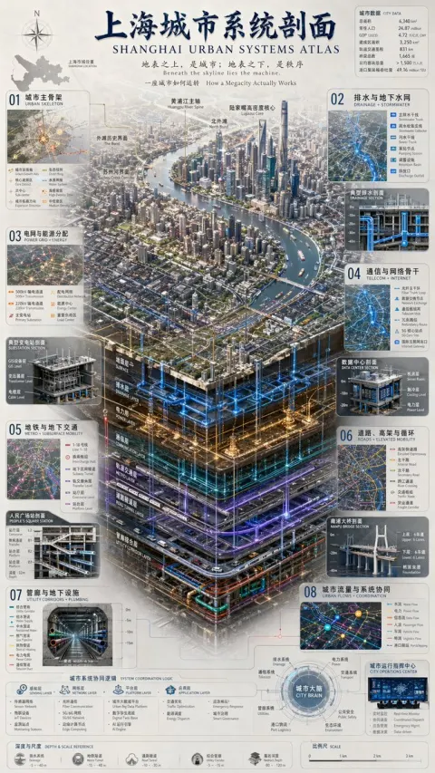
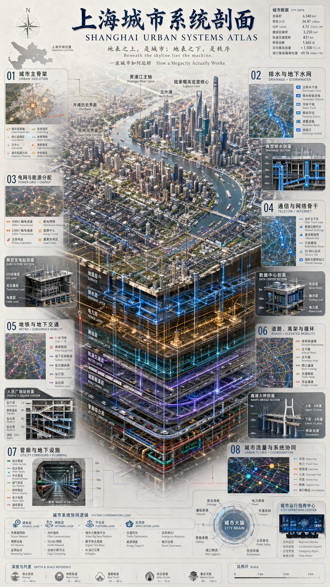
 "type": "complex urban systems atlas infographic",
 "style": "dark background with glowing blue, gold, and purple accents\, highly detailed technical illustration, 3D isometric cutaway",
 "header": {
 "title": "上海\ urban systems atlas SHANGHAI\ URBAN SYSTEMS ATLAS",
 "subtitles": [
 "Above the surface is the city; Beneath the surface is order Beneath the skyline lies the machine.\",
 "How a Megacity Actually Works"
 ]
 },
 "layout": {
 "top_left": "Compass rose and city map labeled 'Shanghai City Area Location SHANGHAI LOCATION'",
 "top_right": "Data table titled 'City Data CITY DATA' with 7 rows of statistics",
 "centerpiece": {
 "description": "highly detailed 3D isometric cutaway render\ of a megacity river landscape",
 "layers": [
 "Ground Layer SURFACE",
 "Drainage Layer",
 "POWER LAYER",
 "Communication Layer"
 "Metro Layer",
 "Road Tunnel Layer",
 "Utility Corridor Layer"
 ]
 },
 "side_panels": [
 { "id": "01", "title": "Urban SKELETON", "elements": "Map with 8 legend items" },
 { "id": "02", "title": "Drainage and Groundwater Network DRAINAGE + STORMWATER", "elements": "Cross-section diagram 'Typical Drainage Section' with 5 legend items" },
 { "id": "03", "title": "Power Grid and Energy Distribution POWER GRID + ENERGY", "elements": "Cross-section diagram 'Typical Substation Section' with 6 legend items" },
 { "id": "04", "title": "TELECOM + INTERNET", "elements": "Cross-section diagram 'Data Center Section' with 6 legend items" },
 { "id": "05", "title": "Metro + SUBSURFACE MOBILITY", "elements": "Cross-section diagram 'People's Square Station Section' with 6 legend items" },
 { "id": "06", "title": "Road, Elevated and Circular ROADS + ELEVATED MOBILITY", "elements": "Cross-section diagram 'Nanpu Bridge Section' with 6 legend items" },
 { "id": "07", "title": "Utility Corridors and Underground Facilities UTILITY CORRIDORS + PLUMBING", "elements": "Cross-section diagram 'Comprehensive Utility Corridors UTILITY CORRIDOR' with 8 legend items" },
 { "id": "08", "title": "URBAN FLOWS + COORDINATION", "elements": "Map diagram 'City Operations Center' with 6 legend items" }
 ],
 "bottom_panels": {
 "system_logic": {
 "title": "City System Coordination Logic",
 "steps": 4,
 "labels": ["Sensing Layer", "Network Layer", "Platform Layer", "Application Layer"]
 },
 "city_brain": {
 "title": "City Brain CITY BRAIN",
 "central_node": 1,
 "peripheral_nodes": 8
 },
 "references": {
 "depth_scale": { "title": "Depth & Scale REFERENCE", "icons": 5 },
 "map_scale": { "title": "SCALE", "markers": 4 }
 }
 }
 }
}